
Originally published on Progress and Poverty on April 9, 2026. Republished on Progress.org with permission.
One of the most consistent objections to Land Value Tax is that “land can’t be valued separately from improvements,” a complaint I initially addressed in my article series, later published as a chapter in my book, Land is a Big Deal.
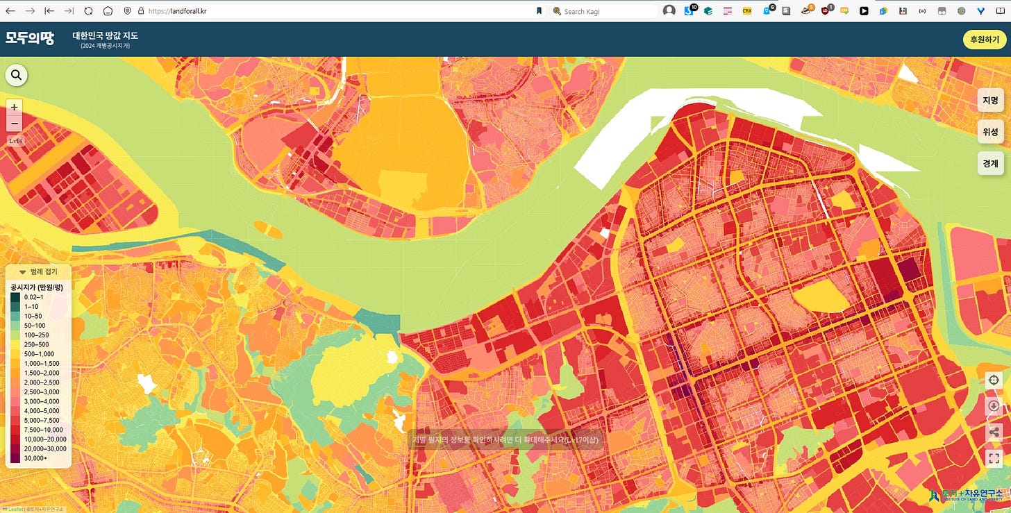
A particularly striking existence proof against this claim is South Korea, a country which not only regularly values all its land (and land values specifically, not just total property values), but which does so annually, and not based on broad regional bands, but down to the individual parcel, accounting for all sorts of hyper-local effects such as road frontage and locational premiums. Furthermore, the Koreans run a tight ship and get the whole operation done in five months flat, at least if official reports are to be believed.
These public land valuations are made freely available for all to inspect and download via public API. Because the land values are free for anyone to use, it’s easy to put them on an interactive web map. One such example is LandForAll.kr, a site produced by Korean researcher Jinsu Lee, which lets you explore per-parcel land valuations for the entire country:
The South Korean land valuation regime is of particular note in recent times because Land Value Tax is gaining momentum both in the US and abroad, and one of the most reliable pieces of pushback is concerns about technical and logistical hurdles.
A particularly salient example is the country of Wales, which under Cabinet Secretary for Finance and Welsh Language Mark Drakeford, recently published the results of an extensive research project on Land Value Tax's feasibility in that country, complete with a deep dive into Land Valuation methodologies. The work itself was farmed out to not one but six separate research groups, whose final reports can be found on this page. Their conclusions are mixed and mostly echo existing conventional wisdom, which can be fairly summarized thus:
- Market-based statistical valuation is the gold standard for total property values (land + improvement), but this method struggles with land valuation because vacant lot sales evidence is thin.
- Machine-learning algorithms have high predictive ability, but struggle when it comes to explainability, and are often seen by the public as mysterious “black boxes.”
- Formulaic area-based methods are a reliable method for tracking overall market values and are much simpler to administrate, but lack precision on a per-parcel basis and are sensitive to administrative assumptions.
These studies were neither blinkered nor provincial—they cited case studies from numerous countries throughout the world and thoroughly engaged with the available academic literature. Nevertheless, none seemed aware of the most relevant example of all, the South Korean system. The closest we got was one single mention in a report by Alma Economics, which buries the lede as follows:
In Korea, for instance, about 1,300 appraisers (2011 data) value sampled plots, with prices extrapolated to adjacent plots
One can hardly blame the Welsh researchers for overlooking the Korean system when I myself only learned of it a few months ago, and only because Korean researchers reached out to me directly. The chief reason I suspect both the Welsh researchers and I missed it is because despite having such an advanced land valuation system, South Korea’s effective tax rate on land is extremely low, and therefore it doesn’t turn up in searches for “countries with land value tax.”
However, now that we’ve found this fascinating example, it’s time to learn from it. My chief sources for this article are:
- 2025 Guidelines for the Survey and Assessment of Official Standard Land Prices and Appendix (in Korean)
- Act on the Public Announcement of Real Estate Prices [Act No. 17459, Enforced Dec. 10, 2020] (in Korean)
- Various Korean researchers I’m in touch with, especially Vitnarae Kang and Jinsu Lee
Mark Drakeford, if you’re reading this, consider this an unsolicited “mini” seventh technical report submitted to your initiative, courtesy of the Center for Land Economics.
How the Koreans Value Land
One big caveat before we proceed—I do not speak Korean, and am heavily relying on machine translation and Korean speaking friends. Any errors or omissions in this article are therefore mine alone.
Three things stand out about the Korean system:
- One special technique I’ve not seen anywhere else
- Otherwise, a reliance on completely standard mass appraisal practice
- A high degree of organizational competence and attention to detail
Korea’s “one special technique” is a particular focus on standard land parcels. Every year, MOLIT, the Korean Ministry of Land, Infrastructure, and Transport, identifies on the order of 500,000 “standard parcels” which serve as valuation anchors for all other parcels in the nation. For context, that’s about 1.6% of Korea’s 31 million total parcels. Each standard parcel is carefully selected to be the most representative parcel for a given area and land type. Nearby parcels of the same category are linked to the local standard parcel they have the most in common with, and valued in direct reference to it. This is called the “Standard Land Price System.”
There are two fundamental outputs of this system: a standard land table, which values each individual “standard parcel” at a specific KRW/square meter rate, as well as a set of adjustment tables which provide factors for every way local parcels can deviate from their referenced “standard parcel.”
Once these two products have been produced, valuing any given parcel’s land is fairly straightforward: apply adjustments for every difference in characteristic the subject parcel has from the standard parcel, then multiply the final rate by your subject parcel’s land size. It’s essentially a Land AVM, simplified to a set of consistent and predictable mechanical rules, calibrated from market evidence, updated on an annual basis.
Centralized or Decentralized? Why not both?
Although the system looks top-down at first glance, and it certainly benefits from strong centralization, it’s actually being simultaneously worked from top, bottom and the middle. Throughout the entire valuation process, MOLIT is in constant bidirectional communication with regional, municipal, and local government officials. While valuing each “standard” parcel is MOLIT’s job, valuing all the other parcels is the responsibility of local governments. This is a clever way to organize responsibilities in a reasonable and scalable way, with the national organizations doing what they do best—ensuring standardization, training, and structure—while local governments do what they do best—sharing and applying irreducible local knowledge of their hometowns.
There’s more to it than just that, though—MOLIT doesn’t do all the standard parcel valuation work itself. In fact, it’s more accurate to say that MOLIT organizes the national effort. The “standard parcel” appraisals themselves are actually performed by private licensed appraisal corporations, and crucially, the rules state that in all but exceptional cases each standard parcel must be valued by at least two different appraisal firms.
Furthermore, a special organization known as the Korea Real Estate Board (KRB) sits in the middle of the process, providing the basic infrastructure for the whole operation. First, the KRB, alongside MOLIT, is the co-author of the guidelines linked above. Second, the KRB provides the mandatory annual training that licensed appraisers must complete to be eligible to participate in the standard price system. Third, the KRB is responsible for all the IT, software, and databases used throughout. Fourth, the KRB is the central hub where a large multi-round national price balancing process occurs. This is where individual appraisers submit their results which are in turn reviewed during a national consultation meeting where failing valuations are flagged for review prior to finalization. Parallel to this, MOLIT separately conducts its own oversight, audit, and review. Finally, the KRB produces and distributes the Land Price Comparison Table, which local governments use alongside the Standard Parcel valuations to complete their local valuations.
Evaluation
How do we know if the South Korean land values are any good? Several mechanisms are in place to test the values against market data, and can best be understood in a western context as a mixture of “mass appraisal” and “fee appraisal” practices and standards. Valuations are checked against prices of recently sold properties, with the building component typically stripped out through conventional cost approach/depreciation estimates. A similar approach is done for properties valued on capitalized income, which are compared to comparable rental income and expense data. Additional statistical checks are made to check the overall uniformity of valuations for similarly located, similarly classified land, with the goal of ensuring that however any individual parcel is valued, it is valued in the same manner as those directly comparable to it. Beyond the basic statistical checks, there are provisions and checklists to ensure that each appraiser submits sufficient evidence and arrives at their valuations through proper approved procedures, with documentation every step of the way, and several rounds of audits.
This is just a high-level gloss, to get into more specifics would require more time (and more translation), but I’m eager to dig into the details (and run my own statistical tests) in a future article.
The Secret Sauce: Diligence & Data
Other than the standard parcel system and Korea’s enviable state capacity, there really isn’t anything in the described methods that you can’t find in any conventional appraisal textbook. They use the three approaches to value just like anybody else—the cost approach, the income approach, and the sales comparison approach. (If you don’t know what those are, I covered them in the first article I ever wrote about appraisal). They also employ hedonic regression, land residual extraction, paired sales analysis, and all the other conventional techniques.
One key advantage the Koreans have is far better datasets than the average anglosphere jurisdiction is used to. The only possible explanation for how the Koreans have achieved this is their mystical oriental powers, most especially a particular magic spell known as “passing a law.” Here’s how it works: a Korean wizard known as a “lawmaker” writes an incantation upon a sacred scroll known as a “bill,” speaks its True Name, such as “The Act on Real Estate Transaction Reporting”, and inscribes upon it a plea that all real estate transactions and their details be swiftly reported to the government. Then, poof! Whenever there’s a real estate transaction, the details are swiftly reported to the government! They don’t stop there, either—similar provisions provide for broad mandatory collection of rental lease information, and there’s also an official government survey which collects income and expenses from a sample of commercial properties, with penalties for refusal or false response.
Joking aside, the contrast with my own country is striking. Here in the US, there are twelve “real estate non-disclosure” states (including my own) where assessors do not have guaranteed access to sales transactions, yet these very same states insist assessors value property “at fair market value,” which is defined in reference to—you guessed it!—sales. And even in the other thirty-eight states, assessors tell me they sometimes struggle with data sparsity issues when it comes to valuing rental and commercial properties. Ironically, tying assessor’s hands doesn’t actually protect anyone’s privacy—that personal data is bought and sold freely on commercial sites like MLS, Costar, and RealPage anyways, often for the benefit of landlords.
Because Korea has access to sufficiently good data, it’s much easier to conduct any kind of property valuation, including land.
Limitations
The Korean system is not perfect, and one can quickly find domestic complaints and critiques of the system. One persistent critique is that historically, official land prices lagged the market to a significant degree. This paper from 2010 found the assessment ratio of land to be about 56%, that is, land was consistently undervalued by about half of prevailing market rates. Over the years that followed, there was an attempt to increase the assessment ratio closer to market value, however in 2023 the Yoon Seok-yeol administration moved to freeze rates and keep them at a lower assessment ratio (Yoon Seok-yeol would later be sentenced to life in prison for insurrection). The new president, Lee Jae-myung, has signaled intentions to raise valuations closer to market rates, targeting 90%, but has not yet done so, keeping the 69% realization rate for now while a five-year plan is being worked out.
Another important detail is that these land valuations play an important role in the real estate market, they have not yet been fully stress-tested as a tax base, because South Korea has no Land Value Tax, and as for the conventional Property Tax it does have, the effective rate is very low. For this reason, whatever level of accuracy and precision has been achieved so far probably sets a floor rather than a ceiling, as the imposition of higher fiscal stakes will demand even further scrutiny.
There are various other debates, critiques, and concerns that turned up in searches, but frankly, I’m not sufficiently well versed in Korean language or politics to give them a full and proper treatment in a short blog post like this, and will save such deep dives for future treatments, which I’ll perform in direct cooperation with Korean experts.
Limitations aside, I’m genuinely impressed. No other country I’ve seen has a system this thorough.
“Sure, but it won’t work here”
Okay, so what does this mean for countries like the US, or Wales?
Let’s briefly assume for the sake of argument that the Korean land valuation system is close to the ideal, and that a Land Value Tax levied upon such a tax base would actually have all the predicted beneficial effects. Even if that were the case, critics could still point out that their country just can’t muster the same state capacity as Korea. In fact, just such an argument was made by the Welsh researchers.
Aside from complaints about the technical and administrative difficulty of land valuations, other objections included the lack of a national cadastre, significant skill gaps in local government, complications created by Wales’ discretionary planning system, insufficient data gathering capabilities, and fundamental legal restrictions.
These objections were not one-offs and were echoed across the research groups, so I don’t want to minimize them. Nevertheless, a path can be paved to a future implementation if we’re willing to think outside the box a little and also willing to start with small, incremental reforms. A good place to start would be a regional pilot project centered on an urban area like Cardiff, much like ongoing local Land Value Return efforts we’ve been nurturing in the United States.
Let’s go over each major objection in turn.
Objection 1: We don’t have a cadastre!
South Korea has a highly centralized national government with exceptional data collection and organization, underpinned by a central land registry which encodes who owns what property, what’s built where, and who sold what to whom at what time. Wales doesn’t have that.
Even worse, the three functions that a cadastre usually represents—land ownership, parcel boundaries, and valuation—are spread across three other separate UK agencies: the Land Registry (which tracks ownership), the Ordnance Survey (which does mapping), and the Valuation Office Agency.
However, we can look at the stories of a few other countries to contextualize how big a limitation this really is. For one, plenty of countries have just taken the plunge and built out state capacity that used to be lacking. Consider Estonia, for instance. Formerly dismissed as a “Second World” country, Estonia is now considered to have one of the most advanced and efficient tax systems in the world (a system which includes a small Land Value Tax). There’s also been some fresh developments in Serbia, which has recently made major strides to modernize and revamp their property tax system. The lesson from these two countries is that the best time to get your valuation infrastructure in order is twenty years ago, but the second best time is today.
We could also consider another country which has many regions and cities with sophisticated property tax systems despite the country itself having no national cadastre whatsoever. Who could possibly think of doing something so bold and reckless?
“We don’t need no stinkin’ cadastres!”

Believe it or not, there is no official land register or cadastre in the USA, nor is there any single document that is sufficient by itself to legally prove ownership over any piece of land.
It’s true that various local agencies like county recorders and property tax assessors will maintain local databases that encode who claims to own this or that parcel, and local governments levy property taxes against those claims, and the system hums merrily along. From a strict legal perspective, however, nobody actually knows for sure who truly owns a particular piece of land until an exhaustive chain-of-title search is conducted which traces every property transfer from buyer to seller all the way back to a “terminal deed,” which declares the original parcel to be the unambiguous legal property of e.g. the King of Spain by right of conquest.
I’m absolutely not kidding about this:
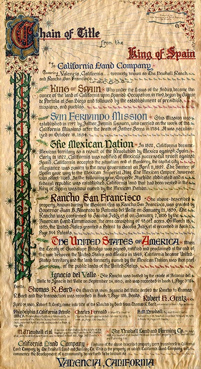
In the US, you don’t really “own” land so much as “strongly claim” to own land in a probabilistic sense, with the ground truth only to be revealed with finality if and when someone digs up all the paperwork. This is why title insurance exists, in case you were wondering (or as Patrick McKenzie calls it, “The $4,000 insurance policy designed to never pay out”).
On top of this, the property databases that do exist in the United States are massively devolved—typically to the county level, sometimes below even that, and there are no universal rules or formats for how deeds and parcel records are maintained and digitized. Nevertheless, many1 American localities are still able to administer property tax systems admirably well.
From a purely technical perspective, you don’t need to wait for the stars to align just to stand up a local database, value property, and mail notices to particular addresses, even if external sources are the final source of truth, not you. There may very well be durable legal barriers that prevent this approach from taking root in Wales, but they should be properly understood as such: legal barriers, not technical ones; for whom the problem is “we need change the law,” not “we don’t know how.”
Look, if a bunch of wild yankee cowboys can pull this off, so can you.
Objection 2: Discretionary Planning System
Wales, like the rest of the UK, has a particularly illegible land use system, in which it’s almost impossible to know ahead of time what will be legally permitted to be built on a particular piece of property. Korea, by contrast, has an extremely legible system where any parcel’s legal uses are highly predictable. Wales’ system of land use permissions is a significant complication for implementing a reliable land valuation system.
To get the full picture, let’s compare various regimes against one another.
On one extreme we have the famous Japanese system of zoning, the statutory use district, which is fundamentally rule-based, highly centralized and standardized, and operates in terms of what is explicitly forbidden, rather than what is permitted. If it’s not forbidden, it’s permitted. (The Korean zoning system is close enough in broad strokes that the two can be considered variants of the same fundamental approach). This article from which the charts below are taken is a good explanation of the Japanese system:
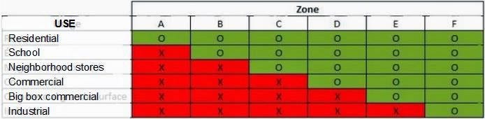
North American zoning, often known as “Euclidean zoning,” is also a rule-based system, but is much more regionally fragmented with no single national standard. The other key difference is that it concerns what is explicitly permitted, rather than what is forbidden. If it’s not permitted, it’s forbidden:
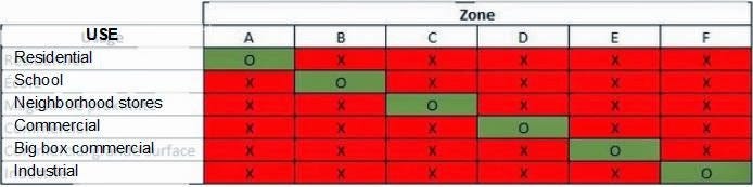
The one saving grace of the North American zoning system is that although local zoning codes can be convoluted and ambiguous, at the very least you can rest assured that what you are and aren’t allowed to build is in fact codified somewhere, in some actually existing local ordinance that you could, in theory, make sense of.
On the opposite extreme is the UK system, or discretionary permission. Under this system, there is no development as-of-right, nor any clear and consistent zone-based rules that make it predictable what may or may not be built where. Instead, permission must be explicitly sought and explicitly approved on a per parcel, per project basis. This makes valuation on a “highest and best use” standard difficult when “highest and best use” can unpredictably change at the whims of a planning board.
The inherent uncertainty of whether planning permission will be granted surely distorts the property market, but property still actually trades hands and gets leased out, and therefore actual selling prices and rental values can still be observed. Some kind of valuation can still be performed in this environment, even if overall precision might be less than what can be accomplished in South Korea.
This is also another case where reforming the law might be a good idea, for reasons entirely apart from facilitating better valuations. Clearer rules of the road for what can and can’t be built will not just make the market more efficient, they would also remove incentives to corruption where local planning officials trade planning permission—and the subsequent uplift in land value—for backroom kickbacks.
Objection 3: Data Gathering Capabilities
Finally, we come to the issue of data gathering limitations.
Suffice it to say, I’ve spent a lot of time researching mass appraisal, I give presentations at assessor’s conferences alongside assessors, and I maintain an open source Automated Valuation Model library that’s being actively adopted in assessor’s offices. I am deeply familiar with the kinds of data that need to be collected in order to pull off a reasonably accurate and defensible land valuation system.
Here’s how any scrappy upstart jurisdiction, anywhere in the world, can collect the data they need.
Financial transactions
The heart of every mass appraisal system is sales and rents. Most valuation jurisdictions have sales, but ideally they should be gathering rental data from leases as well, and also income and expense reports from commercial properties.
What to get:
- Sale price (actual price the real estate transacted for)
- Sale date
- Parcel ID
- Sales validity metadata
- Whether there was a building on the site at time of sale
- “Frozen” parcel characteristics at time of sale
- For leases: price, date, terms, duration, etc.
How to get it:
If you have sovereign authority, pass laws that mandate the regular collection of these. If you don’t, get this information however you can; the private market has likely collected and organized it already, so there’s often the option of just buying it. If it’s not available (or the private market refuses to sell it to you), running a voluntary survey is better than nothing.
How to enrich it:
Sales must be validated before they can be used as either test evidence or predictive fodder for a regression model. Some sales don’t actually reflect the operation of the market, but instead represent data errors or e.g. non-arms length transactions between a father and son for massively reduced prices. Not only does OpenAVMKit include a module for dealing with this, we’ve also written a thorough article that goes through all the most common sales anomalies, how you can detect them, and what the proper validation procedures should be.
Parcel characteristics
These are the physical features of your parcels — what’s actually there on the ground.
What to get:
- Parcel shapefile (the geometry itself)
- Situs address (physical address of the parcel itself)
- Owner’s address (where to send the tax bill)
- Classification information:
- Building type
- Zoning/land use/permission, if known
- “The big five” characteristics2:
- Land size
- Building size
- Building year built
- Building quality (of materials and construction)
- Building condition (e.g. amount of physical depreciation)
- Other characteristics:
- # of bedrooms
- # of bathrooms
- # of units (for a multifamily or commercial property)
- # of floors
How to get it:
Hopefully somebody already has digital parcel geometry for you somewhere. Even if you’re not the source of truth on that, you can always download and copy it for your own use.3 As for the other characteristics, you should be able to tap into your country’s postal system to figure out how to reach the person currently claiming to occupy that parcel, as well as its current situs address. The rest can be measured through mandatory disclosure at time of sale, with regular inspections every few years. However, here’s where modern tech can yield serious savings.
How to enrich it:
In the USA, many appraisal jurisdictions are contracted with vendors like EagleView and NearMap, who provide overhead and oblique aerial imagery, or CycloMedia and NCTech, who provide street-view images. If you have access to imagery like this, you can run open source commodity computer vision models on them to extract valuable characteristics. This lets you encode whether a parcel has a building or not, whether there is visible damage, how many corners the roof has, the presence of certain materials, and many other useful facts. These facts can then be fed through an objective rubric that generates standardized building quality and condition codes.
Additionally, there are many free data sources, such as Overture, which pre-process bulk aerial imagery into building footprints for you, which we used to great effect in our research in Baltimore to overcome local data limitations. Hooks for this functionality are already available for free in OpenAVMKit.
Locational Characteristics
These are factors that have everything to do with where a parcel is, what sorts of amenities it has access to, and generally everything related to location, location, location. They are often significant drivers of value in statistical models.
What to get:
- Street frontage
- Water frontage
- Views
- Topography / slope
- Proximity to various things:
- Central business district
- Parks
- Schools
- Golf courses
- Etc.
How to get it:
You can do this the easy way or the hard way, and I strongly recommend the easy way. The hard way is to “pound the pavement” and send people out to observe all this stuff by hand. We really don’t need to do that anymore.
How to enrich it:
This is the easy way, and the best way. Use GIS tools to automatically calculate this stuff. In OpenAVMKit, we have a dedicated street frontage calculator that leverages Open Street Map data to meticulously calculate street frontage against every parcel at an extremely fine level of detail. We also have the ability to calculate proximity to any arbitrary shape file you provide, not to mention stamp parcels with zoning codes or district names. As for topography, if you have a Digital Elevation Model (which should be available for most countries), you can automatically calculate each individual parcel’s overall bumpiness and average slope. There’s even been a lot of research on calculating viewsheds directly from GIS data. We hope to have all these features available out of the box in OpenAVMKit soon.
Start Small + Do the Least You Can Do
We don’t need to overcomplicate this. Just start small, do the least you can do, and get the ball rolling from there. While a “national” LVT on the scale of an entire country sounds big at first, it’s not so bad when you realize that Wales is smaller than Maricopa County, Arizona, not only in terms of square miles, but also total population and GDP. (Incidentally, Maricopa County has an excellent property assessor’s office and I would be happy to introduce you to their staff).
For Wales, the best place to start is the capital city of Cardiff. Set up your own databases, collect, copy, beg, borrow, and buy what you need to fill up your tables, and enrich the rest using modern GIS techniques. Then, build up some basic valuation models—and please feel free to reach out to me if necessary, I’d be happy to connect you with all the relevant experts. You can (and should) do this well in advance of actually passing an LVT, because it will tell you what the likely effects would be.
Further, please understand that you don’t need to pull off something as sophisticated as South Korea’s models. A first principles analysis of the incentives shows that a much simpler regional approach, which we have dubbed “Least You Can Do” (LYCD) land valuation, will largely have the same beneficial effects as a “platonic land valuation.”
Then, put it on a map and start telling your story.
In conclusion, please enjoy this music video I found of the song “Soda Pop” from the hit movie KPop Demon Hunters, in Welsh:
There are also many that do not administrate property tax “admirably well.”
These are significant statistical drivers of value
If you have to “boil the ocean” and directly process geometry from metes and bounds, then a) you have my condolences, and b) you can at least build a computer system to process these in bulk, flag any overlaps and inconsistencies, and hopefully cut down on the sheer amount of work.